
- Marysvale Canyon, the best known stretch of the Sevier River, is 118 km north of Panguitch
- Sevier River flows through Marysvale Canyon dropping 60 feet per mile
- Ideal rafting conditions are due to the Paiute Reservoir which controls the flow
- Sevier River, East Fork is a designated Blue Ribbon fishing area for rainbow, brown and cutthroat trout
Overview
The Sevier River UT has two main headwaters in southern Utah. As it flows north through Marysvale Valley it is surrounded by peaks reaching 12,189 feet elevation. Passing through Marysvale Canyon it drops 60 feet per mile with steep canyon walls rising on either side for 500 feet.
The South Fork is fed by the Mammoth Creek which originates almost 80 miles away near Cedar Breaks National Monument.
The East Fork starts in Fishlake National Forest, north of Otter Creek State Park.
Location and Information
Marysvale Canyon, the best known stretch of the Sevier River, is 118 km north of Panguitch.
From Cedar City follow the I-15 north to Cove Fort, then Hwy 70 east to Marysvale and Sevier.
Contact the Sevier River Water Users Association at 435-633-4441.
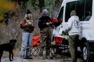
Rafting/Kayaking
The Sevier River offers ideal conditions for kayaking and rafting due to the Paiute Reservoir which controls the flow. The 70-mile stretch of the Sevier River between Panguitch and Salina has Class I-III whitewater sections.
Outfitters in the area offer exciting rafting trips for families and more experienced rafters lasting 2-3 hours.
ATV/OHV Trails
- From Marysvale, Canyon Trail 74 east takes you up Deer Creek from the canyon rest area.
- Canyon Trail 74 west runs from Hoovers Grill back to Marysvale through the uranium mining district.
- From Big Rock Candy Mountain riders can go east up Antelope Canyon to connect with Piute side trail 22.
Biking Trail - Rock Candy Express Bike Trail
- Description: Follows old railroad along Sevier River
- Trailhead: North end of Marysvale Canyon
- Distance: 8-mile paved trail
- Difficulty: Easy
Fishing
The East Fork of the Sevier River is a designated Blue Ribbon fishing area. It runs through a steep-sided canyon for much of its length above Otter Creek Reservoir. It is difficult to fish with lots of steep slopes, brush and rocks. Access is along Hwy 22 from Antimony or Bryce Canyon.
Wildlife Viewing
The Sevier River offers the opportunity to spot bald eagles, golden eagles, red tailed hawks, beaver, muskrat, deer, cougar and black bears. The best place for bird spotting is Marysvale Canyon.
