- Ashdown Gorge Wilderness Area covers 7,043 acres
- It has a range of elevations from 7,500 to 10,500 feet
- Rattlesnake Trail follows Rattlesnake Creek for 5 miles to Potato Hollow Trail
- Potato Hollow Trail runs for 2½ miles from Rattlesnake Trail to the trailhead at the wilderness edge
Overview
The Ashdown Gorge Wilderness Area was named after George Ashdown, an early settler who started a sawmill in the area in 1898. The wilderness area covers 7,043 acres of wilderness with a range of elevations from 7,500 feet to 10,500 feet above sea level. It was officially designated a wilderness area in 1984 and is managed by the US Forest Service.
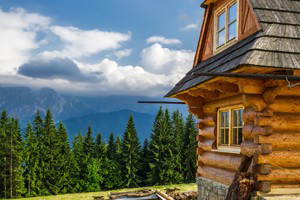
The area is ideal for outdoor recreation with meadows, forests and amazing rock formations. In the north part of the Ashdown Gorge Wilderness is the Twisted Forest, a significant stand of Bristlecone Pines.
Location and Information
The Wilderness area borders the north and western edges of Cedar Breaks National Monument, near Brian Head.
From Cedar City drive north 15 miles on I-15 then south on Hwy 143 approximately 20 miles to reach Ashdown Gorge Wilderness.
Entrance Fees/Opening Times
Free admission.
Access roads to the high country usually open in May and close in October due to deep snow.
Hiking Trails
Although the wilderness is a huge area, there are less than 10 miles of hiking trails. It is possible to hike off-trail taking care to create as little damage as possible to the land.
Rattlesnake Trail
- 5 miles long
- Easy to moderate
- Range 8,000-10,400 elevation
- Follows Rattlesnake Creek
- Crosses the northern boundary of Cedar Breaks running east-west
- It eventually joins Potato Hollow Trail
Potato Hollow Trail
- 2.5 miles long
- Easy to moderate
- Range 8,000-10,400 elevation
- The trail forks to become Blowhard Trail which climbs up Blowhard Mountain
- The other fork goes to the trailhead at the edge of the wilderness
Wildlife Viewing
The area is home to mule deer, yellow-bellied marmots, chipmunks, golden-mantled ground squirrels, voles and mice.
Fun Facts
The ancient Bristlecone Pines may be up to 2,000 years old.